
Land and Sea Use Agreements


Land Use Agreements
Land Rights Act
In 1976, the Parliament of Australia passed the Aboriginal Land Rights (Northern Territory) Act 1976 (Commonwealth) (Land Rights Act).
The Land Rights Act set up the first system in Australia where Aboriginal people could make land claims based on their traditional connections to land. Aboriginal land granted under this system was handed back by the creation of Land Trusts.
The Land Rights Act also created land councils to help administer the land claims process and to manage leasing and land use on Aboriginal land. The Land Rights Act provides the legal framework for progressing social, commercial and economic development activities on Aboriginal land on behalf of traditional Aboriginal owners. Most non-mining development activities on Aboriginal land require an agreement under section 19 of the Land Rights Act. These are commonly referred to as section 19 agreements.
Native Title
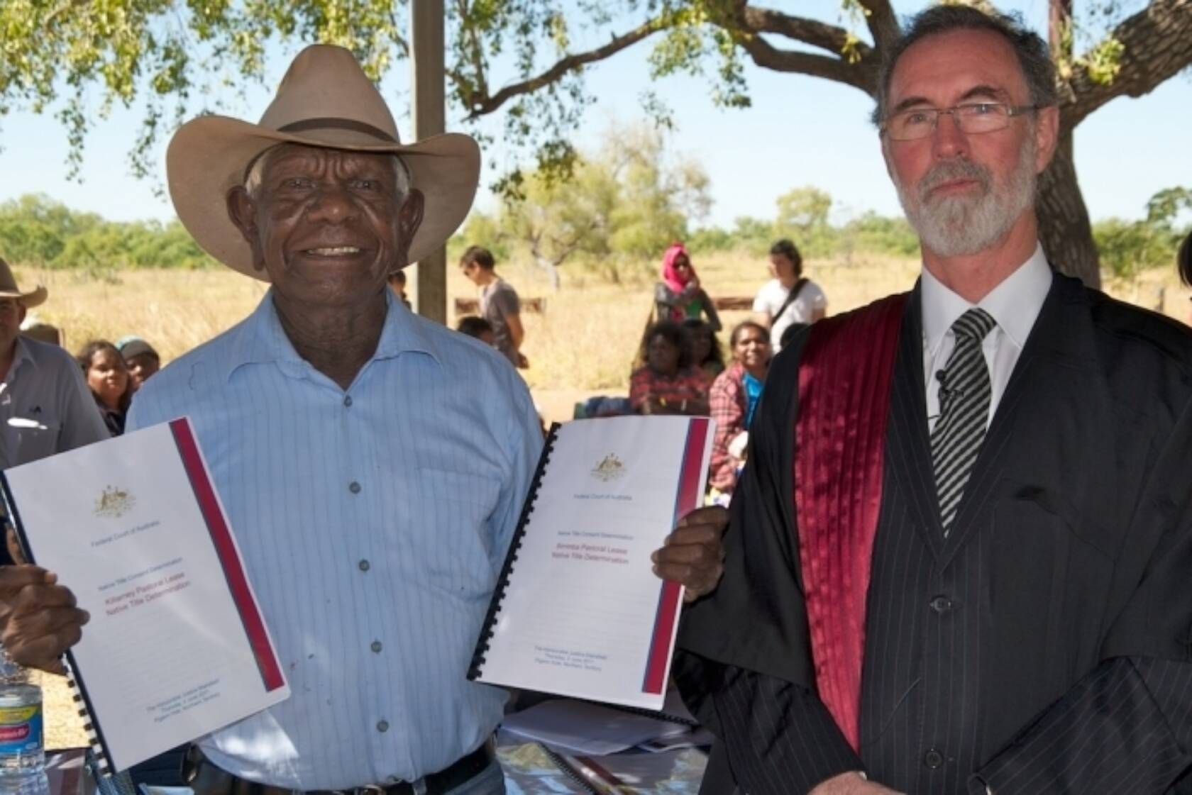
On 3 June, 1992, the High Court of Australia delivered its landmark Mabo decision which rewrote the Australian common law and gave a massive boost to the struggle for the recognition of Aboriginal land rights.
Put simply, the decision said that under Australian law, Aboriginal people have rights to land – rights that existed before colonisation and which still exist. This right is called native title.
By a majority of six to one, the High Court ruled that native title to land is recognised by the common law of Australia, throwing out forever the legal fiction that when Australia was "discovered" by Captain Cook in 1788 it was terra nullius, an empty or uncivilised land.
The case centred on the Murray Islands in the eastern part of the Torres Strait Islands between Australia and Papua New Guinea. The Meriam people, led by Eddie Koiki Mabo, took the action to the High Court to overturn the doctrine of terra nullius.
The judges in the case declared that:
“... the Meriam people are entitled as against the whole world to possession, occupation, use and enjoyment of the lands of the Murray Islands”
It was the first time that the High Court had considered the position of Indigenous people in Australian property law and their judgement was not restricted to the Murray Islands.
Justice Brennan said:
“... there may be other areas of Australia where an Aboriginal people, maintaining their identity and their customs, are entitled to enjoy their native title.”
Reviewing the history of non-Aboriginal Australia, Justice Brennan wrote:
“Aborigines were dispossessed of their land parcel by parcel, to make way for expanding colonial settlement. Their dispossession underwrote the development of the nation.”
Settlements, land grants and pastoral leases:
“... spread across the continent to dispossess, degrade and devastate the Aboriginal peoples and leave a national legacy of unutterable shame. The acts and events ... (of Aboriginal) dispossession ... constitute the darkest aspect of the history of this nation... The nation as a whole must remain diminished unless and until there is an acknowledgment of, and retreat from, those past injustices.”
— Justices Dean and Gaudron
While recognising the existence of native title, the High Court also confirmed the sovereignty of governments and said that they had the power to acquire native title providing they kept within the law, particularly the Racial Discrimination Act 1975.
Sections of the mining and pastoral industries, and conservative politicians, reacted angrily to the High Court's decision and urged the Commonwealth Government to overturn it by legislation. They conducted a massive fear campaign against the newly-established land rights of Indigenous Australians.
Land Use Agreements
The number of micro-enterprises, private business, Government and community development activities occurring on Aboriginal land has steadily increased over the last decade.
As of 30 June 2022, NLC’s land management responsibilities include overseeing more than 900 section 19 Land Use Agreements that are in place over 4,150 parcels of land. Land parcels under agreement can vary in size from a designated Lot in an Aboriginal community that may be up to 1,000 m2 to a mustering / collection licence over an area that may cover up to 10,000 km2.
The section 19 agreement process gives traditional Aboriginal owners an opportunity to consider, develop terms and conditions and the right to consent to or reject proposals on their land and seas.
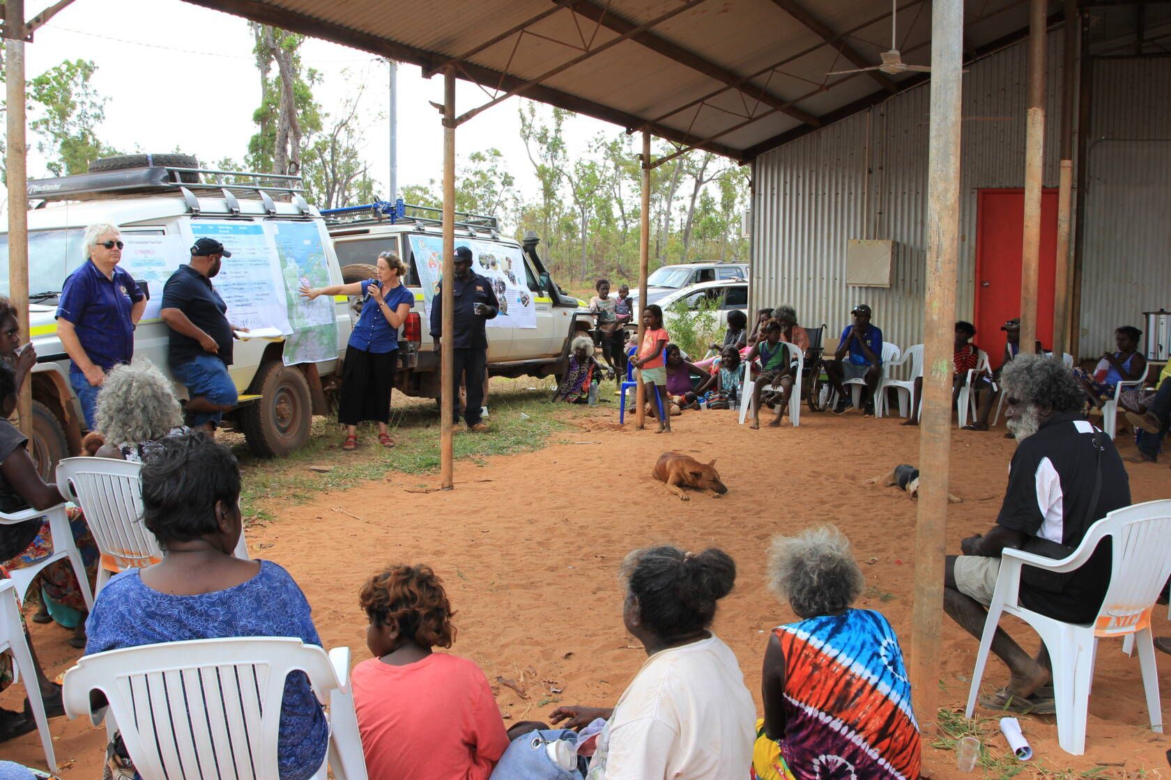
NLC carries out consultations and negotiations on behalf of traditional Aboriginal owners with those interested in carrying out social, commercial and economic development activities on Aboriginal land and waters. NLC must ensure that any land use proposal is fair and equitable.
Multi-disciplinary teams within the NLC, comprising of Land Use project coordinators, regional office staff, lawyers and anthropologists, undertake a rigorous assessment of all land use proposals prior to going to consultation. As required, the NLC will also engage external experts to assist with the assessment of land use proposals. Using this process, traditional Aboriginal owners are given the opportunity to make an informed decision in accordance with their traditional decision-making processes. Affected Aboriginal people and communities are also given an opportunity to express their views in relation to land or water use proposals.
Where informed consent is given, the NLC may direct the appropriate Aboriginal Land Trust to enter into a section 19 Land Use Agreement with the proponent.
Commercial fishing
From 1 January 2023, section 19 Land Use Agreements are required for any commercial fishers or fishing tour operators wishing to access Aboriginal waters.
There are several existing long-term access agreements in place for Aboriginal waters in the Northern Territory, access to these specific areas does not require a section 19 Land Use Agreement whilst the long-term access agreement is in place. These long-term access agreements are between traditional Aboriginal owners and the Northern Territory Government
Agreements are also required for the closed seas around the Crocodile Islands area and the Castlereagh Bay area in East Arnhem Land.
Please view the commercial fishing page or the fishing tour operators page for more detailed information.
Land Use Agreements Forms
Download a S19 Land Use Agreement Expression of Interest application form by clicking the button below.
Download a S19 Land Use Agreement Expression of Interest Blue Form by clicking the button below.
The S19 Land Use Agreement Blue Form applies to commercial fisher and fishing tour operators.
FAQs: Land USE AGREEMENTS
sea Use Agreements
Fishing Tour Operators
Fishing tours and guided fishing is an integral part of NT tourism and occurs in all waters including Aboriginal waters. The term ‘Aboriginal waters’ refers to waters overlying Aboriginal land.
Permission is required to enter Aboriginal land and waters, including for Fishing Tour Operators. Permission to fish in Aboriginal waters is provided via Section 19 Land Use Agreements administered by the NLC.
The following information outlines access arrangements for Fishing Tour Operators who would like to access Aboriginal waters from 1 January 2023.
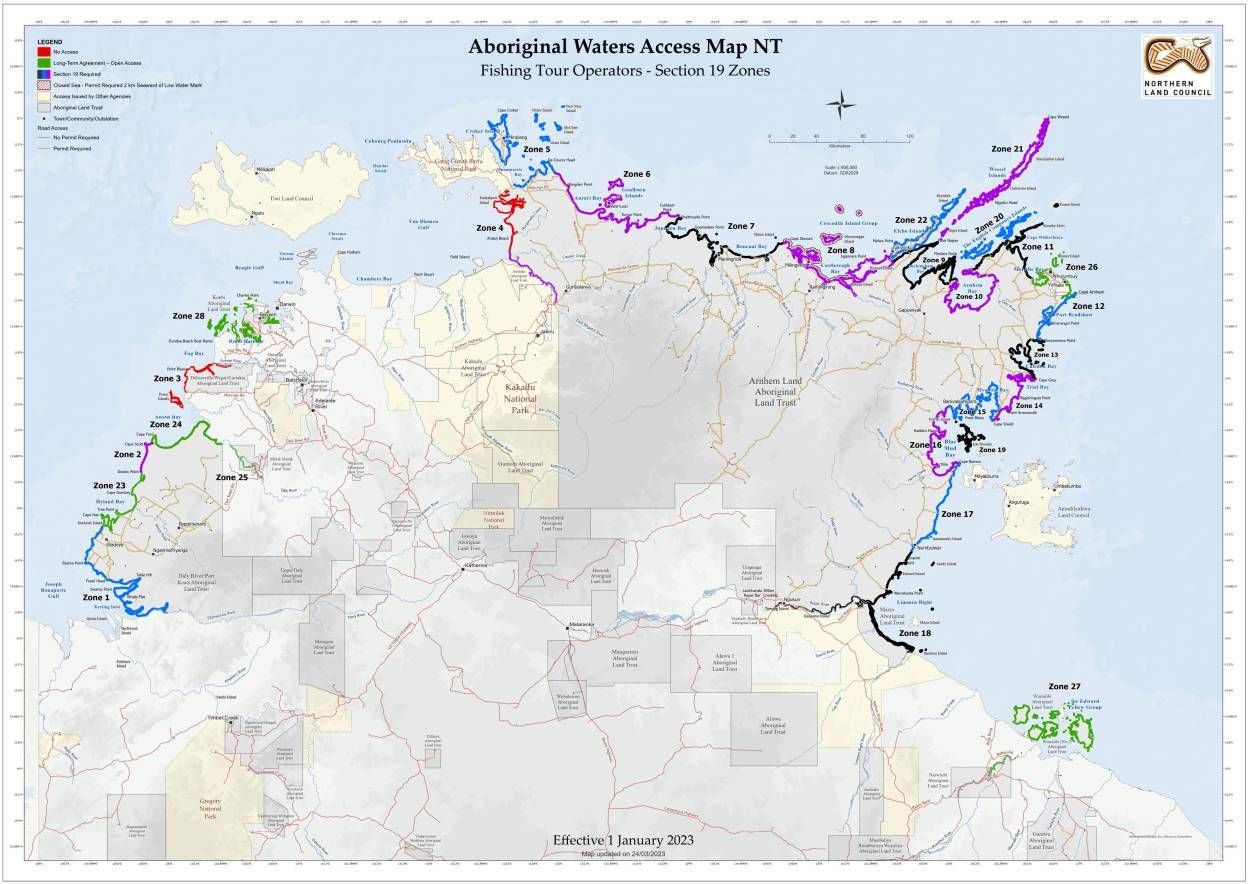
Green Zones
No section 19 required
Fishing Tour Operators and their clients who would like to access Aboriginal waters marked in green on the Fishing Tour Operator Aboriginal Waters Access Map are able to do so without the need to apply for a Section 19 Land Use Agreement.
The Traditional Aboriginal Owners of these areas have entered into an access agreement with the Northern Territory Government to allow people to access their waters.
Black, Blue and Purple Zones
Section 19 required
Fishing Tour Operators who would like to access Aboriginal waters marked in black, blue and purple on the Fishing Tour Operator Aboriginal Waters Access Map need to apply for a Section 19 Land Use Agreement. Please click on the link below to apply.
Fishing Tour Operators who have a valid Section 19 agreement in place, please click the link below to apply for a Recreational Fishing Permit for your clients.
Red Zones
Fishing Tour Operators are not allowed to access Aboriginal waters marked in red on the Fishing Tour Operator Aboriginal Waters Access Map.
Access is restricted to the Fishing Tour Operator sector for Aboriginal waters in the following locations:
- Along the Finniss coast and the Peron Islands area (including the Little Finniss)
- Areas around the Mini Mini system down to an area just north of the mouth of the East Alligator River (including Saltwater Creek and Murgenella Creek)
Aboriginal Waters Access Map - Fishing Tour Operators
Unauthorised entry onto Aboriginal land and waters could result in a fine of 50 penalty units (currently $15,650) under Commonwealth law, or 8 penalty units (currently $1,408) under Northern Territory law. The acceptance of insurance claims on Aboriginal land may also rely on a valid permit.
Please contact Darwin Head Office at reception@nlc.org.au or (08) 8920 5100. If you would like any further information, please contact the Sea Country team at seacountry@nlc.org.au or (08) 8980 1925
This information was updated on 19 July 2023
View all Aboriginal Waters Access Maps in link below:

Commercial Fishing
Commercial fishers operate in various waters including Aboriginal waters. The term ‘Aboriginal waters’ refers to waters overlying Aboriginal land.
Permission is required to enter Aboriginal land and waters, including for Commercial Fishers. Permission to fish in Aboriginal waters is provided via Section 19 Land Use Agreements administered by the NLC.
The following information outlines arrangements for commercial fishers who would like to access Aboriginal waters from 1 January 2023.
Green Zones
No section 19 required
Commercial fishers who would like to access Aboriginal waters marked in green on the Commercial Fishing Aboriginal Waters Access Map are able to do so without the need to apply for a Section 19 Land Use Agreement.
The Traditional Aboriginal Owners of these areas have entered into an access agreement with the Northern Territory Government to allow people to access their waters.
Black, Blue and Purple Zones
Section 19 required
Commercials fishers who would like to access Aboriginal waters marked in black, blue and purple on the Commercial Fishing Aboriginal Waters Access Map need to apply for a Section 19 Land Use Agreement. Please click on the link below to apply:
Red Zones
Commercial fishers are not allowed to access Aboriginal waters marked in red on the Commercial Fishing Aboriginal Waters Access Map.
Access is restricted to the Fishing Tour Operators fishing sector for Aboriginal waters in the following locations:
- Along the Finniss coast and the Peron Islands area (including the Little Finniss)
- Areas around the Mini Mini system down to an area just north of the mouth of the East Alligator River (including Saltwater Creek and Murgenella Creek)
Aboriginal Waters Access Map - Commercial Fishing

Unauthorised entry onto Aboriginal land and waters could result in a fine of 50 penalty units (currently $15,650) under Commonwealth law, or 8 penalty units (currently $1,408) under Northern Territory law. The acceptance of insurance claims on Aboriginal land may also rely on a valid permit.
Please contact Darwin Head Office at reception@nlc.org.au or (08) 8920 5100. If you would like any further information, please contact the Sea Country team at seacountry@nlc.org.au or (08) 8980 1925
This information was updated on 19 July 2023
View all Aboriginal Waters Access Maps in link below: